Definition of
The Colorado Plateau
Definition of The Colorado Plateau
The Colorado Plateau is a roughly pear shaped 130,000 square mile subdivision of a physiographic area known by geologists as the "Intermontane Plateaus". The Intermontane Plateaus are divided into three subdivisions; The Columbia Plateau, The Colorado Plateau and the Basin and Range Province. Each subdivision is further divided into regions.
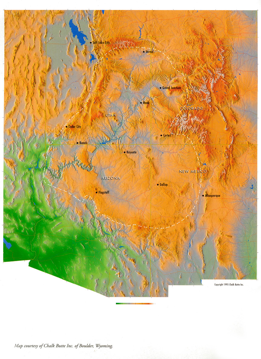
The Colorado Plateau contains seven regions; The High Plateaus of Utah, The Uinta Basin, Canyon Lands, The Navajo Section, The Grand Canyon Section, The Datil Section and the Acoma-Zuni Section. The Acoma-Zuni Section is a new division that is comprised by lands taken from The Datil Section. All of the regions are located within the boundaries of four states; Arizona, Colorado, New Mexico and Utah. Monument Valley is the approximate center of the The Colorado Plateau.
The Colorado Plateau has also been described as the middle section of the Colorado River drainage. Although this description holds for the majority of The Colorado Plateau, two other rivers need to be mentioned - The Sevier and The Rio Grande. The Sevier River is the primary drainage in the "High Plateaus of Utah" region within The Colorado Plateau. The Sevier River drains into Sevier Dry Lake near Delta, Utah. The Rio Grande River is the primary drainage in The "Datil" region of The Colorado Plateau in New Mexico and parts of Arizona.
The Colorado Plateau's landmass is one of the oldest generally intact tectonic plates on the planet. Although this region has been uplifted several thousand feet, it has avoided the massive uplifting to the east characterized by the Rocky Mountain System and to the west by the Basin and Range Province. Geologists believe that the earths crust is thicker under the The Colorado Plateau. This thicker crust protects the area from the typical geologic mountain building that has occurred in the American west. The geologic movement that does occur is exposed as linear bands like The Vermillion Cliffs and tilted plates like Capitol Reef. The mountain ranges on the plateau are typically volcanic or of volcanic origin. The San Francisco Peaks near Flagstaff, Arizona are primarily volcanic in origin but the Henry Mountains near Hanksville, Utah and the La Sals and Abajo's near Moab, Utah are laccoliths. A laccolith is a mountain range formed by the uplift from volcanic pressure that could not quite break through to the surface.
One element that the plateau has not escaped is erosion. In fact when you combine the erosive power of water, a fairly stable landmass and a few hundred million years you create the most unique sculpture park in the world. Simply put, there is nothing on the planet, on any continent, like The Colorado Plateau.
The following is a general description of the boundaries of
The Colorado Plateau subdivision:
The northern boundary is the southern flank of the Uinta Mountains extending from approximately Utah Lake near Provo to Dinosaur National Monument near Vernal, Utah.
The eastern boundary is the most complex as is descends southeast from Dinosaur National Monument toward Glenwood Springs, Colorado and curves southwest around the San Juan Mountain Range, then angles southeast to Albuquerque, New Mexico.
The southern boundary is represented by a geologic formation known as The Mogollon Rim (pronounced - muggy-one) near Payson, Arizona. The southern boundary runs generally east-west forming a convex curve that extends from the Nevada Border at Lake Mead Reservoir southeast to Payson, following the Mogollon Rim, and then sweeping northeast toward Albuquerque, New Mexico.
The western boundary is Interstate I -15 as it runs northeast from The Virgin River Canyon near the Nevada Border and St. George, Utah to Utah Lake near Provo, Utah.